World War II Tunnels, Gibraltar
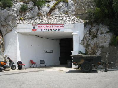
During the Second World War, Gibraltar witnessed the most extensive phase of tunneling in its history, playing a crucial role in the North Atlantic and Mediterranean arenas. The war prompted a substantial increase in the length of tunnels, expanding from 7 miles (11 km) to 25 miles (40 km).
At the war's outset, the civilian population was evacuated, and the garrison size was significantly augmented. Numerous fresh tunnels were excavated to accommodate the expanded garrison and store vast quantities of provisions, equipment, and ammunition. This tunneling endeavor was undertaken by four specialized tunneling companies from the Royal Engineers and the Canadian Army.
A new Main Base Area was established in the southeastern part of Gibraltar, along the Mediterranean coast of the peninsula. This location protected the potentially hostile Spanish mainland while connecting tunnels were constructed to link it with the existing military bases on the western side. Two tunnels, known as the Great North Road and the Foss Way, were painstakingly dug, spanning nearly the entire length of the Rock, interconnecting the majority of the wartime tunnels.
The tunnels served as an underground city, capable of accommodating the entire 16,000-strong garrison and storing enough food to sustain them for 16 months. Within this subterranean complex, various facilities were established, including an underground telephone exchange, a power generating station, a water distillation plant, a hospital, a bakery, ammunition storage areas, and a vehicle maintenance workshop.
Want to visit this sight? Check out these Self-Guided Walking Tours in Gibraltar. Alternatively, you can download the mobile app "GPSmyCity: Walks in 1K+ Cities" from Apple App Store or Google Play Store. The app turns your mobile device to a personal tour guide and it works offline, so no data plan is needed when traveling abroad.
World War II Tunnels on Map
Sight Name: World War II Tunnels
Sight Location: Gibraltar, Gibraltar (See walking tours in Gibraltar)
Sight Type: Attraction/Landmark
Guide(s) Containing This Sight:
Sight Location: Gibraltar, Gibraltar (See walking tours in Gibraltar)
Sight Type: Attraction/Landmark
Guide(s) Containing This Sight:
Walking Tours in Gibraltar, Gibraltar
Create Your Own Walk in Gibraltar
Creating your own self-guided walk in Gibraltar is easy and fun. Choose the city attractions that you want to see and a walk route map will be created just for you. You can even set your hotel as the start point of the walk.
Rock of Gibraltar Walking Tour
You really can’t avoid the Rock of Gibraltar when visiting the British Overseas Territory on the southern tip of the Iberian Peninsula. Just like the streets lined with British-style red phone booths and historical buildings, this prominent limestone rock formation, overlooking the Strait of Gibraltar from an elevation of 426 meters (1,398 feet) above sea level, creates a distinctive atmosphere... view more
Tour Duration: 2 Hour(s)
Travel Distance: 4.5 Km or 2.8 Miles
Tour Duration: 2 Hour(s)
Travel Distance: 4.5 Km or 2.8 Miles
Gibraltar Introduction Walking Tour
"Burn your boats," said the Berber commander Tariq bin Ziyad, addressing his troops. The year was 711 AD. Tariq had landed in Gibraltar with his small force, invading the Kingdom of the Visigoths. The men were nervous. Their numbers were few compared to the enemy. After burning their only means of escape, they went on to conquer the Iberian Peninsula.
The Rock of Gibraltar was called... view more
Tour Duration: 1 Hour(s)
Travel Distance: 1.9 Km or 1.2 Miles
The Rock of Gibraltar was called... view more
Tour Duration: 1 Hour(s)
Travel Distance: 1.9 Km or 1.2 Miles


