Tajo de Ronda (Ronda Gorge), Ronda (must see)
The Ronda Gorge (El Tajo de Ronda) splits the city's heart in two. The two parts are the Moorish Old Town (La Ciudad) and Little Market (El Maercadillo), the modern section. The Ronda Gorge, formed by erosion, is 394 feet deep and 223 feet wide. The River Guadalevin cuts through the canyon, fed by the snow melt of the Snowy Mountains (Sierra de las Nieves).
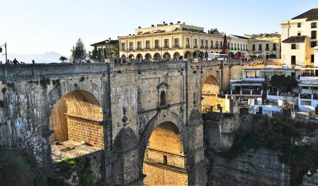
The high, Romanesque arches of the New Bridge (Puente Nuevo) span the irrepressible Guadalevin. Views from the top of the span encompass the entire canyon and the valleys stretching below, all the way to the hills of the Grazalema Mountains (Sierra de Grazalema). It is possible to walk along the banks of the Guadalevin following steep trails from the Old Town (La Ciudad).
Clinging to the sides of the gorge, one walks deeper and deeper, the cliffs rising above. The river is powerful. Flour mills once used river water to power their machines until the landslide of 1917 wiped them out.
The trail for walking through the canyon starts at the Roman Bridge (Puente Romano) on the east bank. There is no trail on the west bank. At the bottom, by the river, are several ponds connected by mill canals. A good view of the west bank can be had from the Hostel Los Molinos, located in an old water mill.
The most historic well connecting with the Ronda Gorge is in the House of the Moorish King (Casa del Rey Moro). Houses and well were erected in the 14th century. The well goes down to the river's edge. It is the major piece of hydraulic engineering remaining from the old Nasrid Kingdom. The well is called Water Mine (La Mina de Agua).
Steps were carved into the rock walls of the canyon. Christian slaves carried water up from the river in water skins. The Ronda Gorge is used in Hemingway's novel, "For Whom the Bell Tolls." There is a scene of Republicans throwing Nationalists from the cliffs, possibly in Ronda. Old customs die hard. But the views are fantastic.
Want to visit this sight? Check out these Self-Guided Walking Tours in Ronda. Alternatively, you can download the mobile app "GPSmyCity: Walks in 1K+ Cities" from Apple App Store or Google Play Store. The app turns your mobile device to a personal tour guide and it works offline, so no data plan is needed when traveling abroad.
Tajo de Ronda (Ronda Gorge) on Map
Sight Name: Tajo de Ronda (Ronda Gorge)
Sight Location: Ronda, Spain (See walking tours in Ronda)
Sight Type: Attraction/Landmark
Guide(s) Containing This Sight:
Sight Location: Ronda, Spain (See walking tours in Ronda)
Sight Type: Attraction/Landmark
Guide(s) Containing This Sight:
Walking Tours in Ronda, Spain
Create Your Own Walk in Ronda
Creating your own self-guided walk in Ronda is easy and fun. Choose the city attractions that you want to see and a walk route map will be created just for you. You can even set your hotel as the start point of the walk.
Ronda Introduction Walking Tour
Ancient rock paintings found in the area tell us Ronda was settled by Celts, who called it "Arunda." Phoenicians and Romans followed the Celts. Muslim rule was established in 713 by the Umayyads, who called it the "Castle of Rundah." Islamic domination ended in 1485 when Rodrigo, Duke of Cadiz, conquered the city.
Seen from the air, Ronda is breathtaking. It is in two parts,... view more
Tour Duration: 2 Hour(s)
Travel Distance: 2.8 Km or 1.7 Miles
Seen from the air, Ronda is breathtaking. It is in two parts,... view more
Tour Duration: 2 Hour(s)
Travel Distance: 2.8 Km or 1.7 Miles

